The World’s 7 Highest Ropeway Systems: Spectacular Cable Cars Above the Clouds
There is a distinct moment when altitude ceases to be an abstract number and becomes an unforgettable physical reality. Flying at 10,000 metres isolates you in a pressurised cabin, but swaying inside a glass-paned gondola above an active glacier with nothing beneath you but mountain air and jagged cliffs—makes the scale of our planet intimately personal.
The world’s highest and most ambitious ropeways are marvels of mechanical engineering. They serve as alpine thoroughfares, extreme tourism gateways, and vital urban links. For readers of Tattvam News Today, we have compiled and verified the definitive guide to the 7 most extraordinary high-altitude ropeways on Earth. This curated selection includes iconic global record-holders alongside personal family narratives from our own journeys through the legendary valleys of Gulmarg, Chamonix, and Zermatt.

1. Dagu Glacier Gondola (Sichuan, China)
The Highest Passenger Cable Car in the World
- Base Station: 3,617 metres
- Official Summit Altitude: ~4,843 metres (15,889 ft) via Guinness World Records (Local station plaque notes 4,860 m).
- Length & Stages: 3 kilometres (1.86 miles) operated in a single, continuous stage, and Journey Time ~10 mins
- Car Capacity: 8 passengers per detachable cabin (Doppelmayr system with 36 units).
- Main Attraction: The terminal gives direct access to the stark, dramatic landscape of the Dagu Glacier. At the summit, visitors can step inside “The Loneliest Café in the World,” a heated coffee house equipped with panoramic glass viewing windows.
- Geographical Range & Environs: Located within Heishui County in the Aba Tibetan and Qiang Autonomous Prefecture. The system climbs the southern flank of the Qinghai-Tibetan Plateau. Due to the extreme altitude, genuine oxygen deprivation is common; automated oxygen supplementation is integrated directly into the summit facility.
- Nearest City: Chengdu (~300 km / 6 hours’ drive) or Heishui County Seat (~10 mins drive).
- Nearest Airport: Jiuzhai Huanglong Airport (JZH) or Chengdu Shuangliu International Airport (CTU).
- Best Time to Travel: October to November for the dual experience of golden autumn foliage and heavy snowfall.
- Cost of the Gondola Ride: ~CNY 180 for the cable car, Scenic area entry of ~CNY 60, and sightseeing bus of ~CNY 70 (total ~CNY 310).
- Pro Tip: Do not attempt to run or move quickly immediately after stepping off the gondola. Spend your first 15-20 minutes inside the heated terminal station or the café to allow your body to adapt to the sudden drop in air pressure before exploring the glacier observation boardwalks.
2. Teleférico de Mérida Mukumbarí (Mérida, Venezuela)
The Longest and Second-Highest Mountain Ropeway
- Base Station: 1,577 metres
- Official Summit Altitude: 4,765 metres (15,633 ft).
- Length & Stages: A massive 12.5 kilometres (7.76 miles) journey broken into 4 distinct stages, and the Journey Time ~50 mins in total.
- Car Capacity: Large-scale aerial tramway cabins holding up to 60 passengers per car.
- Main Attraction: The final terminal drops visitors at Pico Espejo (Mirror Peak), offering an unobstructed view of Pico Bolívar, Venezuela’s highest peak (4,978 m).
- Geographical Range & Environs: Spans the northern spur of the Andes mountain range. The lower tier begins in the bustling mountain city of Mérida, moving tourists through varied ecological zones from lush subtropical cloud forests to the high, windswept alpine paramo fields.
- Nearest City: Mérida City.
- Nearest Airport: Alberto Carnevalli Airport (MRD) or Juan Pablo Pérez Alfonzo Airport (VIG) in El Vigía.
- Best Time to Travel: December to February (dry season) for the clearest morning sky and unobstructed views of the surrounding peaks.
- Cost of the Gondola Ride: ~$40 USD for international tourists (~$20 USD for Venezuelan citizens).
- Pro Tip: Due to the massive 3,188-metres vertical ascent, pack clothing for entirely different climates. You will start the journey in short sleeves in warm Mérida city and exit the final stage into freezing, windswept conditions at Pico Espejo, where temperatures routinely drop below zero.
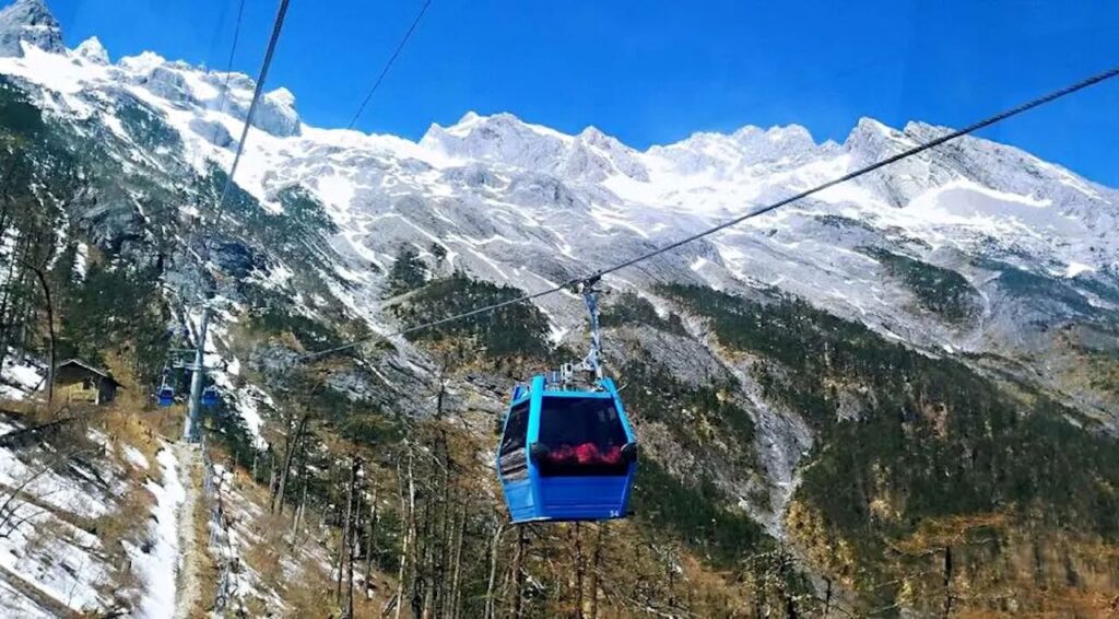
3. Jade Dragon Snow Mountain Ropeway (Yunnan, China)
The Sacred Glacier Route
- Base Station: ~3,356 metres
- Official Summit Altitude: 4,506 metres (14,783 ft).
- Length & Stages: 2.9 kilometres (1.8 miles) scaled in 1 continuous stage, and the Journey Time ~11 mins
- Car Capacity: 8 passengers per enclosed gondola car.
- Main Attraction: The upper station exits onto an outdoor wooden boardwalk built directly over the permanently snow-capped Glacier Park. Visitors can climb an additional flight of stairs along the ridge to top out at an accessible viewing deck at 4,680 metres.
- Geographical Range & Environs: Situated in Lijiang, Yunnan Province. The Jade Dragon Snow Mountain (Yùlóng Xuěshān) massif features 13 distinct peaks, sacred to the indigenous Naxi people. The surrounding valleys host the scenic Blue Moon Valley, famed for its brilliant turquoise terrace pools.
- Nearest City: Lijiang Old Town (~15 to 25 km away).
- Nearest Airport: Lijiang Sanyi International Airport (LJG).
- Best Time to Travel: November to March for pristine, clear mountain snowpacks and optimal visibility.
- Cost of the Gondola Ride: ~CNY 180 for the main glacier cableway (total park entrance fees and eco-buses can add another ~CNY 150-200).
- Pro Tip: Purchase canned oxygen from pharmacies in Lijiang City before heading out to the mountain, as prices quadruple at the park gates. The steep rise from the lower valleys causes rapid acclimatisation strain, and inhaling oxygen periodically along the summit boardwalk prevents sudden altitude headaches.
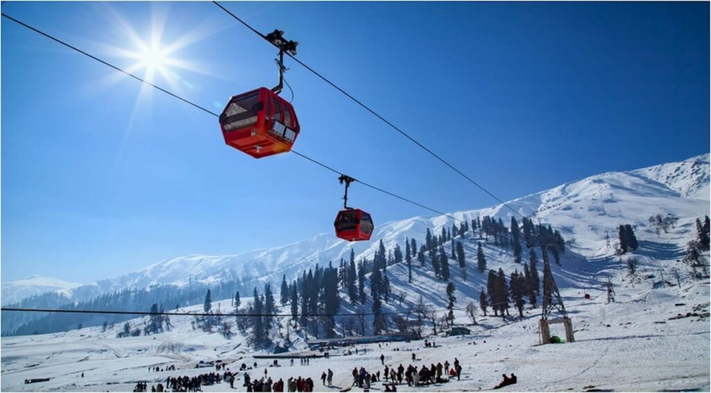
4. Gulmarg Gondola (Jammu & Kashmir, India)
Asia’s Highest and Longest Alpine System
- Base Station: 2,650 metres
- Official Summit Altitude: ~3,979 m (Phase 2 station), with hiking access to higher ridges around 4,390 metres (14,400 ft).
- Length & Stages: 5 kilometres total (~7 km cable run), divided into 2 core operational phases, and Journey Time ~15-20 mins
- Car Capacity: 6 passengers per enclosed POMA gondola cabin.
- Main Attraction: Phase 2 unloads directly onto the high, alpine ridges of Apharwat Peak, granting unmatched views of Nanga Parbat (8,126 m) on clear days. In the winter months, it serves as the primary gateway to some of the deepest backcountry powder skiing in Asia.
- Geographical Range & Environs: Located in the majestic Pir Panjal Range of the Western Himalayas. The base town of Gulmarg is a premier Indian hill station, historically favoured for its lush meadow-based golf courses in summer and world-class alpine winter sports infrastructure.
- Nearest City: Srinagar (~50 km away).
- Nearest Airport: Srinagar International Airport (SXR).
- Best Time to Travel: January to February for heavy snow activities and skiing; April to June for lush, clear alpine vistas.
- Cost of the Gondola Ride: ₹700 INR (~$9 USD) for Phase 1 and ₹900 INR (~$11 USD) for Phase 2.
- Pro Tip: Phase 2 tickets regularly sell out weeks in advance during peak seasons. Always book your tickets exclusively online on the official e-ticketing portal beforehand, and plan your excursion for the earliest morning slot to avoid heavy alpine cloud cover that typically rolls in by midday.
Our Personal Family Experience at Gulmarg Gondola
We arrived in Gulmarg with high hopes of riding Asia’s highest gondola up to Apharwat Peak, but the weather had other plans. It was a quick day trip from Srinagar and we had to head to Pahalgam the next morning. Heavy rain and thick clouds had already set in, and locals at the base station told us the gondola was not operating due to strong winds. With no advance booking and the system shut down, there was no point queuing at the counter. We stood in the rain watching the empty cables disappear into the mist, feeling quite disappointed. It was a clear reminder of how fast mountain weather can change. Still, the lush green meadows looked beautiful even in the rain. We’ll definitely return on a clear day to experience the full ride and those views of Nanga Parbat.
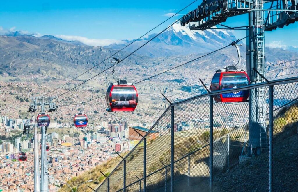
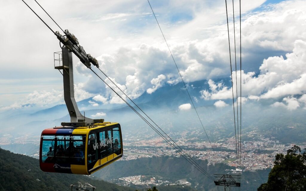
5. Mi Teleférico (La Paz & El Alto, Bolivia)
The World’s Highest Urban Transit Grid
- Network Base: ~3,650 metres
- Official Grid Altitude: Ranges from 3,650 metres up to 4,150 metres (13,615 ft) at its upper terminals.
- Length & Stages: A vast, multi-line municipal network spanning over 30 kilometres across 11 interconnected lines (including the Red, Yellow, and Purple commuter lifelines).
- Car Capacity: 10 passengers per urban gondola unit, departing continuously every 12 seconds.
- Main Attraction: Unlike alpine tourist lifts, this is a fully flying subway system. It carries over 300,000 daily passengers, offering sweeping commuter views of the urban red-brick canyon of La Paz offset by towering glacial peaks.
- Geographical Range & Environs: Navigates the high-altitude bowl of the Cordillera Real in the Andes. The network directly bridges the socio-economic gap between the administrative hub of La Paz and the expansive, flat plateau city of El Alto.
- Nearest City: La Paz / El Alto metropolitan area.
- Nearest Airport: El Alto International Airport (LPB), the world’s highest international airport.
- Best Time to Travel: May to October (the dry winter season) brings crystal-clear blue skies ideal for high-altitude photography.
- Cost of the Gondola Ride: ~3 BOB (~$0.45 USD) per single line ticket, making it the most affordable high-altitude system globally.
- Pro Tip: To experience the most dramatic view of the entire city layout, take the Yellow Line (Línea Amarilla) up to El Alto just before sunset. Watch the thousands of city lights turn on across the mountain bowl while the snow-capped Illimani peak glows pink in the background.
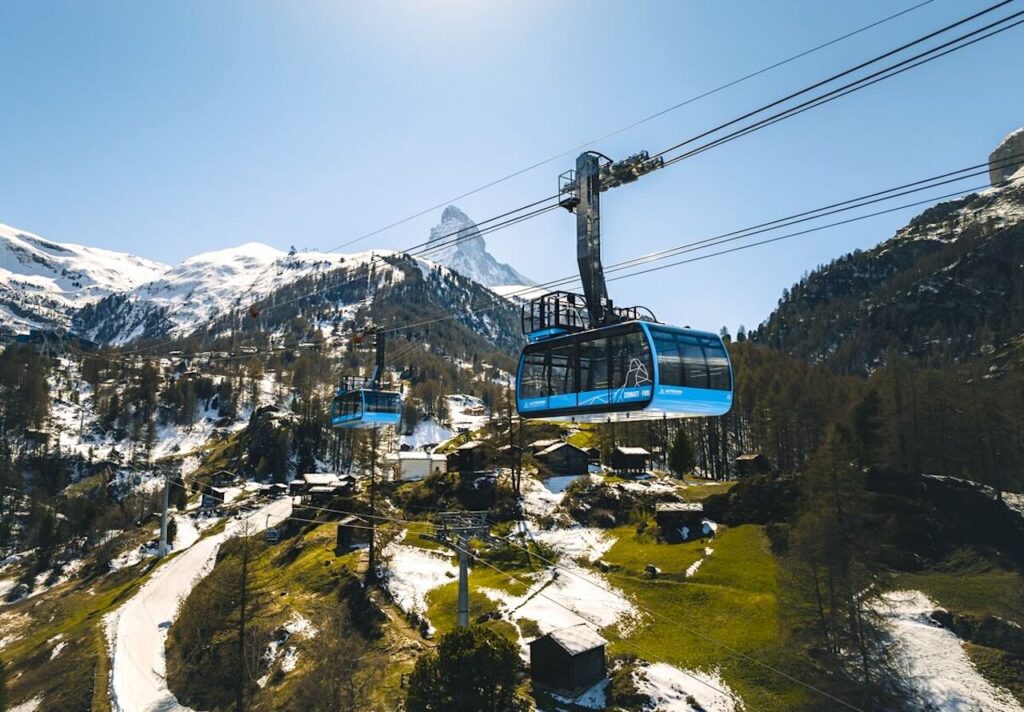
6. Matterhorn Glacier Paradise (Zermatt, Switzerland)
Europe’s Highest Mechanical Viewpoint
- Base Station: Zermatt 1,608 metres
- Official Summit Altitude: 3,883 metres (12,740 ft).
- Length & Stages: Multi-stage transit starting from Zermatt town, culminating in the advanced Matterhorn Glacier Ride 3S tri-cable system from Trockener Steg to the peak.
- Car Capacity: 28 passengers per premium, heavy-duty 3S cabin (including special cabins encrusted with Swarovski crystals and clear glass floors). • Main Attraction: The mountain terminal is carved entirely inside the rock face of the Klein Matterhorn. An elevator inside the cliff delivers you to an outdoor 360° platform looking directly at the iconic, jagged pyramid profile of the Matterhorn (4,478 m). It also grants entry to the subterranean Glacier Palace carved deep under the ice cap.
- Geographical Range & Environs: Set deep within the Pennine Alps of the Valais Canton. The base village of Zermatt is a strictly car-free resort destination renowned for historic wooden chalets, the Gornergrat cogwheel railway, and year-round glacial skiing options.
- Nearest City: Zermatt (Car-free; closest vehicle parking is at Täsch, 5 km away).
- Nearest Airport: Zurich Airport (ZRH) or Geneva Airport (GVA), followed by a scenic 3.5-hour train journey.
- Best Time to Travel: Year-round; winter for premium Snow-sports and July-August for optimal alpine hiking weather.
- Cost of the Gondola Ride: Varies seasonally; typically between CHF 100 and CHF 120 ($110-$135 USD) for a round-trip ticket.
- Pro Tip: Maximise the Swiss Travel Pass if you are traveling with your family. Always request the free Swiss Family Card when purchasing your adult passes; it allows children aged 6 to 15 to travel completely free on the entire rail network and grants a steep 50% discount on the Glacier Paradise cable cars.
Our Personal Family Experience at the Matterhorn
Nothing really prepares you for that first clear view of the Matterhorn when you step off the train in Zermatt. It simply towers there like a giant stone pyramid exactly like the Toblerone wrapper, only far sharper and more imposing in real life. We took the kids up to Glacier Paradise on a bright sunny day and the ride felt like entering another world. Green meadows gave way to rock, then pure ice and snow. Standing on the open 360° platform with the Matterhorn staring right back at us was unforgettable. But the highlight for everyone was descending into the Glacier Palace walking through those glowing blue ice tunnels carved 15 metres beneath the glacier surface. Magical, a little eerie, and completely silent. The kids’ wide-eyed faces said it all. It’s one of those experiences that stays with you long after you’re back in the valley.
Read more about our personal experiences:
Zermatt Travel Guide: Matterhorn, Gornergrat & Glacier Paradise
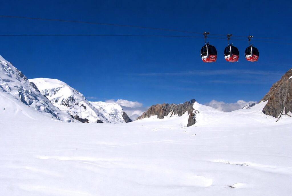
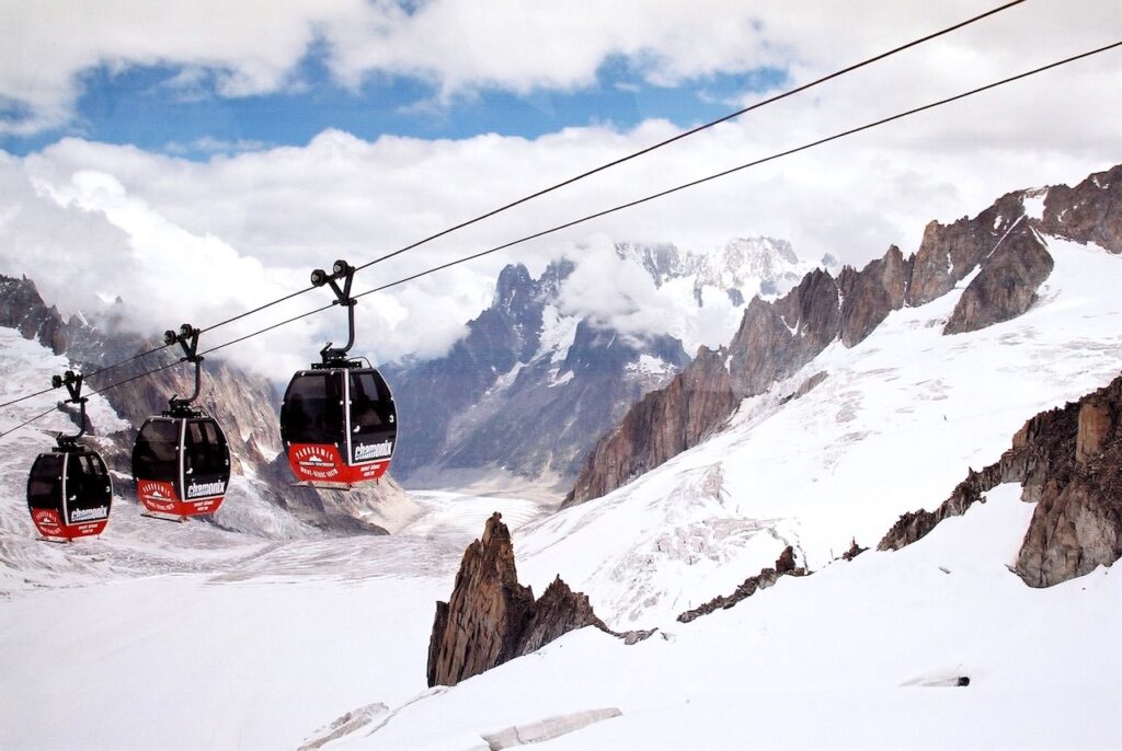
7. Vallée Blanche / Panoramic Mont Blanc (Chamonix, France to Courmayeur, Italy)
The Ultimate Cross-Border Glacial Crossing
- Peak Station: 3,842 metres (France-Italy border station)
- Official Transit Altitude: Traverses heights between 3,462 metres and 3,842 metres (12,605 ft) at the peak terminal.
- Length & Stages: A breathtaking 5-kilometre (3.1 miles) open-air span hanging across international borders. It acts as the central span connecting France’s Aiguille du Midi to Italy’s Pointe Helbronner. Open-air crossing time ~35 mins.
- Car Capacity: Small, iconic 4-passenger pulse cabins that travel grouped in clusters of three along an extended, unsupported cable line.
- Main Attraction: Passengers spend 30 to 35 minutes floating directly above massive, active crevasse fields on the Géant and Vallée Blanche Glaciers. At the French head, you can experience the “Step into the Void” glass observation box; on the Italian side, you transfer to the rotating, circular cabins of the Skyway Monte Bianco.
- Geographical Range & Environs: Spans the heart of the world-famous Mont Blanc Massif in the Graian Alps. The base towns on either side are alpine legends: Chamonix (France) stands as the historic birthplace of mountaineering, while Courmayeur (Italy) offers alpine thermal spas, fine Aosta Valley dining, and stunning southern-face rock walls.
- Nearest City: Chamonix-Mont-Blanc (French side) or Courmayeur (Italian side).
- Nearest Airport: Geneva International Airport (GVA), roughly 1 hour and 15 minutes by shuttle bus to Chamonix.
- Best Time to Travel: Late May to September. This specific peak-to-peak connection closes entirely during winter and severe high-wind events.
- Cost of the Gondola Ride: ~€95 to €115 EUR ($100 $125 USD) depending on bundle combinations with the main Aiguille du Midi tramway.
- Pro Tip: Never leave your passport at the valley hotel. Although the alpine link connects two Schengen countries without routine frontier checkpoints, sudden high-wind closures or technical issues can suspend the ropeway while you are on the Italian side. If stuck, you will have to return to France by road transit through the Mont Blanc Tunnel, where official police document checks are common.
Our Personal Family Experience crossing the Alps
Riding the little Panoramic Mont Blanc cabins from Aiguille du Midi across to Pointe Helbronner remains one of the wildest things we’ve done as a family. You’re suspended in these small pods high above the vast Vallée Blanche, gently swaying (sometimes not so gently) over endless crevasses and glacier fields that seem to go on forever. Spotting tiny mountaineering tents pitched far below on the ice made it feel like another planet. Crossing straight into Italy with no border hassle was a fun bonus. But the altitude hits fast we climbed over 2,800 vertical metres in about twenty minutes. One of us suddenly felt dizzy and weak on the top platform, so we lay flat on the deck until the feeling passed. A sharp reminder that these mountains are beautiful but demand respect. Still, we were grinning the whole way across that frozen wonderland.
Read more about our personal experiences:
Chamonix Travel Guide 2026: The Alpine Adventure That Still Gives Me Goosebumps 21 Years Later
Important: Understanding Acute Mountain Sickness (AMS)
Ropeways can take you from valley floors to over 10,000-13,000 feet (3,000-4,000 m) in minutes, so AMS risk is real. Symptoms usually start above 8,000-10,000 feet (2,500-3,000 m), especially with rapid ascent, and include headache, dizziness, nausea, fatigue, and shortness of breath. It becomes much more common above 10,000 feet (3,000 metres), and almost everyone experiences some symptoms if they ascend quickly to 11,000+ feet (3,350+ metres). We have experienced this firsthand during rapid ascents in Chamonix and Zermatt, as well as during more gradual climbs to Leh and high-altitude locations like Khardung La (17,582 ft / 5,359 metres), Chang La (17,688 ft / 5,391 metres), and Pangong Tso (13,862 ft / 4,225 metres).
AMS is very real, and it can affect anyone, even the fittest and most active people. Just because it didn’t happen on earlier high-altitude trips doesn’t guarantee it won’t happen next time.
Key precautions: Ascend gradually when possible and move slowly at the top. Drink plenty of water and avoid alcohol. Eat light, high-carb meals. Consider Diamox (after consulting a doctor) and carry canned oxygen. Acclimatise for a day if flying into high cities like La Paz or Lijiang.
If symptoms appear: Stop ascending, rest, and descend if they worsen. Mild cases usually improve quickly with descent. Seek medical help for severe symptoms.
Respecting altitude is the best way to enjoy these spectacular rides safely.
For further details, read our post “Comprehensive Guide on Acute Mountain Sickness (AMS)”
Final Thoughts: Chasing Views Above the Clouds
From the record-breaking heights of Dagu Glacier to the thrilling cross-border journey over Vallée Blanche, these seven ropeways highlight extraordinary feats of engineering and the sheer majesty of high mountains. What makes them truly special is how they blend adventure with everyday life, especially Mi Teleférico in Bolivia, the world’s highest urban cable car network that carries hundreds of thousands of locals daily at over 3,650 metres. Some rides thrilled us, others taught us valuable lessons about mountain weather and preparation, but all left us with lasting memories.
Whether you seek extreme altitudes, family adventures, or simply a different perspective on the world, these sky-high journeys are worth every bit of effort. Pack your sense of adventure, book ahead when you can, and go experience the world from above the clouds.