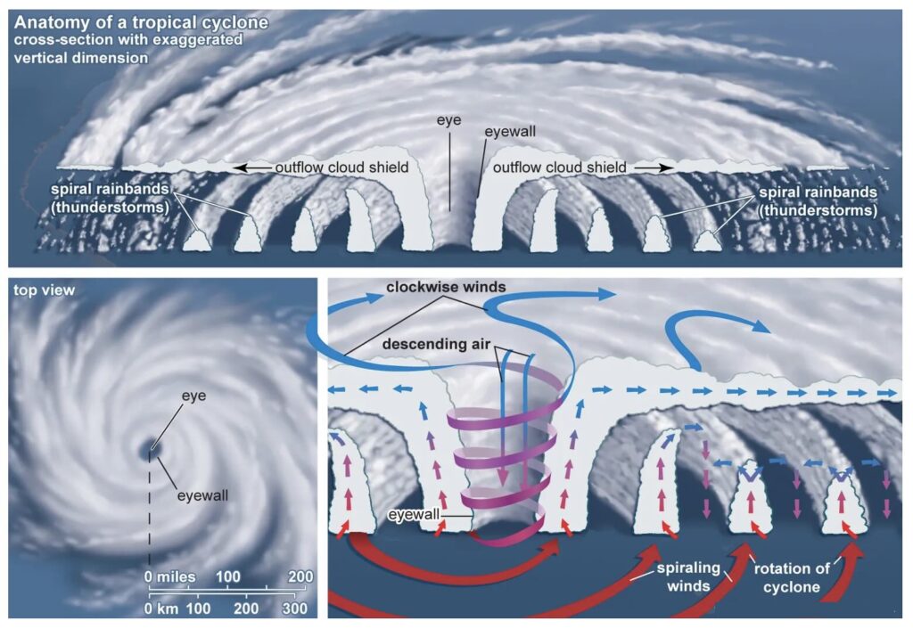
Why Cyclones Intensify
The
severity of a cyclone depends on how
much energy it can draw from the sea. Warm waters, high humidity, and minimal
vertical wind shear (differences in wind
speed at various altitudes) create ideal conditions for intensification.
Slow-moving storms often become
more destructive, as they linger longer over warm seas, feeding on energy and expanding in size.
Conversely, strong upper-level winds can tear a storm apart, reducing its strength before landfall.
In recent years, rising ocean temperatures and changing wind patterns have led to
more frequent and stronger cyclones, a direct outcome of global climate
warming.
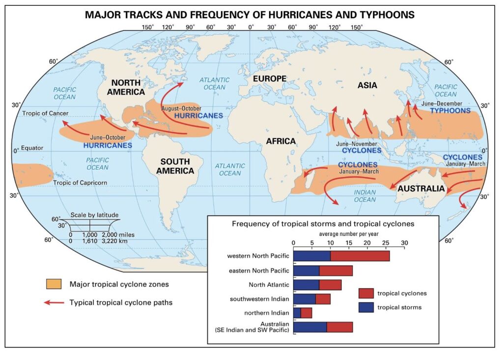
Cyclone Hotspots Around the World
Some ocean basins are far more prone to cyclones than others:
- Western Pacific (Philippines, Taiwan, Japan): Known for the world’s strongest typhoons such as Haiyan (2013) and Uwan (Fung-wong) now nearing the
Philippines with 240 km/h winds.
- Bay of Bengal (India, Bangladesh, Myanmar): Warm waters and a funnel-shaped coast amplify storm surges, making landfall particularly devastating.
- Atlantic (Caribbean and Gulf of Mexico): Home to hurricanes like the Great Hurricane of 1780 and many modern-day storms
hitting Florida and the Caribbean islands.
- South China Sea, Arabian Sea, and Australian coasts: Increasingly active due to unusual sea temperature spikes.
Interestingly,
Kota Kinabalu in Malaysian
Borneo is known as the
“Land Below the Wind”
, as it lies just south of the typhoon belt – a rare tropical zone largely spared from
these tempests.
Cyclone Seasons and Patterns
Cyclones follow predictable
seasonal windows, forming mainly between
June and November when seas are warmest.
- In the North Indian Ocean, storms peak around May-June and October-November.
- The Atlantic and Caribbean see activity from June to November.
- The Western Pacific experiences almost year-round threats, especially between July and October.
High
wind shear during monsoons or cooler months prevents storm formation, which is why these deadly systems are seasonal despite tropical climates.
The World’s Most Destructive Cyclones
Over centuries, cyclones have left deep scars on human history:
- Great Bhola Cyclone (1970, Bay of Bengal): Up to 500,000 deaths in what remains the deadliest cyclone on record.
- Cyclone Nargis (2008, Myanmar): Over 138,000 lives lost, massive flooding across the Irrawaddy Delta.
- Typhoon Haiyan (2013, Philippines): One of the most intense landfalls ever recorded.
- The Great Hurricane of 1780 (Caribbean): Claimed more than 22,000 lives.
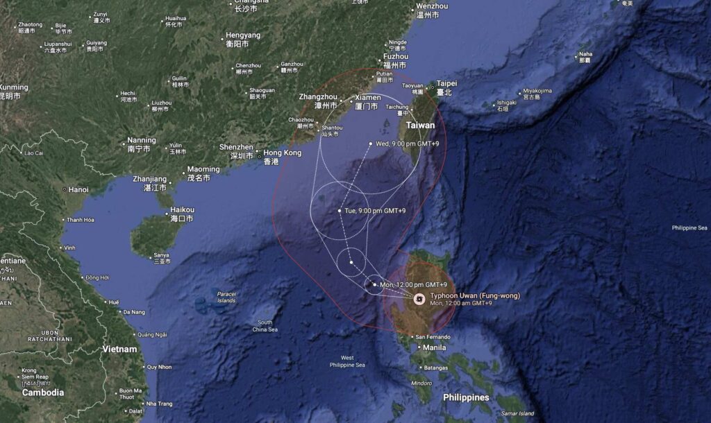
Today, 0n 9th November 2025,
Super Typhoon Uwan (Fung-wong) threatens to join this infamous list. Nearly
a million people have been evacuated from the Philippines’ Aurora province as Uwan approaches with
winds near 240 km/h,
storm surges up to 5 metres, and torrential rains following closely on the heels of
Typhoon Kalmaegi just days earlier. Across the globe, another powerful storm has battered the
Caribbean, underscoring how these disasters are becoming disturbingly frequent.
What’s in a Name? Typhoon, Hurricane, or Cyclone?
Though the names differ, they all refer to the
same weather phenomenon — a powerful tropical storm.
- In the Atlantic and Northeast Pacific, it’s a hurricane.
- In the Northwest Pacific, it’s a typhoon.
- In the Indian Ocean and South Pacific, it’s a cyclone.
Classification depends on
wind speed:
- Tropical Depression: below 63 km/h
- Tropical Storm: 63-116 km/h
- Cyclone/Typhoon/Hurricane: above 116 km/h
- Severe Cyclone or Category 5: above 250 km/h, capable of catastrophic damage.
The Road Ahead: Forecasting and Preparedness
Understanding how cyclones form, evolve, and behave is essential for
forecasting and saving lives. Early warning systems, real-time satellite data, and coastal evacuation drills have already saved thousands of lives compared with decades past.
However, as
climate change warms oceans further, experts warn that
storms like Uwan may become more intense, last longer, and reach new regions once thought safe. Improving preparedness — from coastal planning to international cooperation — remains humanity’s best defence against nature’s most violent storms.