Lipulekh at the Crossroads: Navigating History, Sovereignty, and Geopolitics in the India-Nepal Border Dispute
Introduction
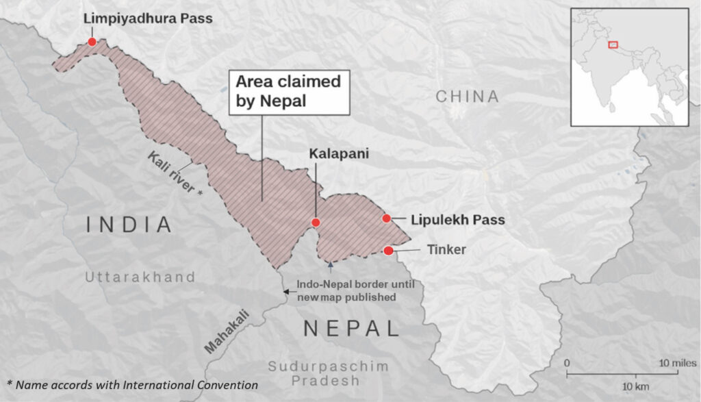
The Lipulekh dispute stands at the heart of one of South Asia’s most complex and geopolitically consequential border conflicts. This disagreement involves India and Nepal, two neighboring countries tied by centuries of cultural and geographic bonds, yet divided by differing interpretations of historical treaties and maps. The conflict focuses on control over the Lipulekh Pass and surrounding areas, such as Kalapani and Limpiyadhura, in Uttarakhand’s Pithoragarh district. Nepal asserts ownership over these lands, citing the 1816 Treaty of Sugauli and historical maps, whereas India maintains administrative and military control, citing British colonial records. The dispute has ramifications for regional security, international relations, trade, and the lives of those in the borderlands.
Historical Origins: Treaties and Cartographic Legacies
The roots of the dispute trace back to the aftermath of the Anglo-Nepalese War when the British East India Company and the Kingdom of Nepal signed the Treaty of Sugauli in 1816. This treaty defined the Kali River as the western border of Nepal. However, the source of the Kali River remains disputed. Nepal claims that the river begins at Limpiyadhura, while India identifies a point near Lipulekh or Kalapani as the source. The distinction is crucial—Nepal’s interpretation puts Lipulekh and surrounding sites inside its territory, whereas India’s reading aligns with administrative convenience and historical colonial surveys.
Throughout the 19th century, British surveyors altered their identification of the Kali River’s origin. Initial maps marked the river originating from Limpiyadhura, supporting Nepal’s claim. After 1856, British mapping practices shifted the source downstream. The boundary then shifted westward, aligning with British India’s administrative interests. No clear bilateral treaty ever formalised these shifts; informal agreements, political disengagement, some other interests of Nepal or lack of capacity on Nepal’s part may have played a role in the silence during the period.
Evolution of Territorial Claims: Changing Maps and Administrative Practices
Nepal’s case rests heavily on historical maps and treaties. It points to documents that show the river originating at Limpiyadhura, arguing that India’s control over 606 square kilometers—including Lipulekh, Kalapani, and Limpiyadhura—violates Nepal’s sovereignty. Nepal maintains that India has relied on a selective reading of the river’s origin, aimed at securing strategic territory.
India’s claim originates from nearly a century of administrative control inherited from the British. Survey maps drawn by the British Survey of India, particularly those from 1879, 1924, and subsequent years, formed the baseline for border demarcation. During the 1980s and 1990s, India and Nepal formed the Joint Technical Committee (JTC), which resolved nearly all outstanding issues, with this area notably left unresolved. The Indian position relies on administrative records, revenue accounts, and the maintained presence in the region since 1962—the year the Sino-Indian War transformed border security protocols in the Himalayas.
Strategic Importance: A Corridor for Military and Trade
Lipulekh Pass sits at a vital junction between India, Nepal, and China’s Tibet Autonomous Region. Control of the pass offers India not only a military advantage but also provides a channel for trade and access to religious pilgrimage routes such as Kailash-Mansarovar. After 1962, the Indian government increased military presence in this region to monitor Chinese advances. In May 2020, the Indian Defense Minister inaugurated an 80-kilometer road connecting the pass to Pithoragarh, drastically reducing travel times and improving logistical efficiency. This infrastructure development heightened friction with Nepal, which views such moves as encroachment on its territory.
Nepal responded with forceful diplomatic protest and released a revised official political map in May 2020, including the disputed areas in its national territory. Nepal’s objections also extend to bilateral agreements between India and China that allow trade through Lipulekh without Nepal’s consultation. Such exclusions are seen as violations of Nepal’s sovereignty and raise concerns about the trilateral dynamics in this sensitive region.
Diplomatic Tensions and Political Dynamics
The Lipulekh conflict has placed strains on the diplomatic relationship between India and Nepal, intensifying since the early 1980s. The JTC resolved 97 percent of border issues, yet failed to address the dispute over Lipulekh, Kalapani, and Limpiyadhura. Political momentum for resolution has flagged, and bilateral mechanisms remain largely inactive in recent years. India views Nepal’s activism—such as publishing new maps and amplifying the dispute—as provocative. Nepal interprets India’s infrastructural expansions and continued presence as coercive measures.
Internally, the dispute has gained traction within Nepal’s political factions, often being utilized to rally nationalist support and strengthen political mandates. At the same time, Nepal has experienced a shift in its geopolitical alignment, with Chinese influence gradually increasing amid cautious engagement with India. China, keen to avoid regional destabilization, urges Nepal to resolve the issue bilaterally, refraining from direct involvement.
Core Issues: Geography, Sovereignty, and Historical Legitimacy
At its core, the Lipulekh dispute revolves around two intersecting themes—geographical interpretation and claims of sovereignty. Nepal’s assertion depends on identifying a more upstream source for the Kali River, thereby placing the contested region within its sovereign territory. India maintains its stance based on inherited colonial boundaries and post-independence administrative continuity. The difference reflects not just cartographic debates but questions of historic legitimacy and the complexity embedded within colonial legacies.
India consistently emphasizes its sustained administration, historical documentation, and the necessity of military control for national security. Nepal, on the other hand, insists on the recognition of its sovereignty, referring to treaty-based evidence and historical maps. Both countries invoke history, yet arrive at different conclusions, producing a diplomatic impasse.
The Unresolved Silence: Nepal’s Inaction and Historical Ambiguity
A key feature of this dispute remains Nepal’s prolonged silence on changing British mapping practices from the mid-19th century until formal objections arose late in the 20th century. British surveys shifted the Kali River’s source from Limpiyadhura to Lipulekh and Kalapani, thereby quietly moving the boundary westward. Questions remain about whether Nepal was aware of, acquiesced to, or unable to challenge these shifts. Concessions or political priorities may have led Nepalese rulers to deprioritize resistance to British cartographic changes.
Administrative and revenue records during the colonial period reveal overlapping claims and periods of Nepalese governance in some areas before 1962. After the Indo-China war, India strengthened its military hold, making the region a strategic outpost in the Himalayas. Nepal’s formal objections only crystallized in 1997 and grew after the opening of the Lipulekh Pass for increased trade and pilgrimage in 2015 and 2020, underscoring the recent urgency of the issue.
Regional Geopolitics: India, Nepal, and China
The Lipulekh dispute illustrates broader South Asian geostrategic rivalries, bringing India, Nepal, and China into a tense and sensitive alignment. India has pursued strategic autonomy in the region, balancing security concerns with infrastructural investments and diplomatic outreach. Nepal, facing internal pressures and increasing Chinese influence, finds itself navigating sovereignty claims, nationalist discourse, and pragmatic diplomacy.
China’s presence adds another dimension. The dispute remains bilateral between India and Nepal, with China encouraging dialogue and remaining wary of direct involvement. The issue acts as a proxy for competing interests in the Himalayas, impacting the broader balance of power in the region. Regional security, trade routes, and cross-border issues all hinge upon the outcome of this dispute.
Pathways for Resolution: Dialogue and Diplomacy
Resolution of the Lipulekh dispute demands dedicated diplomatic engagement and evidence-based negotiation. Both India and Nepal must commit to historical transparency, recognizing the weight of colonial legacies without being hamstrung by them. India’s approach should balance strategic interests with neighborly goodwill and constructive channels for dialogue. Nepal, meanwhile, needs to consolidate domestic consensus and pursue proactive, evidence-led diplomacy.
The ideal path forward involves joint technical surveys, exchange of archives, and mechanisms for compensation or land-swap if mutual recognition of conflicting claims becomes unfeasible. Such efforts must avoid politicization, prioritize regional stability, and reinforce the shared interests of both countries. Peaceful settlement will solidify trust and cooperation, influencing South Asia’s future.
Conclusion
The Lipulekh border conflict serves as a vivid example of how history, geography, and politics remain deeply intertwined in shaping national boundaries. The dispute reveals colonial legacies that continue to affect bilateral relations, create friction in the geopolitics of the Himalayas, and influence domestic and international policies. India and Nepal must now move beyond historical impasses and prioritize diplomacy for sustainable peace.
As both countries seek to resolve the Lipulekh issue, their efforts will determine the stability and future direction of regional partnerships. Only through committed dialogue and respect for historic realities will they build enduring trust and harmony on one of South Asia’s critical frontiers. The Lipulekh dispute remains a litmus test for their ability to navigate the past and look forward to a peaceful and prosperous future.