India–Pakistan Rivalry at Sir Creek: US Interest, Energy Potential, and Historical Flashpoints
Introduction — Why Sir Creek Matters
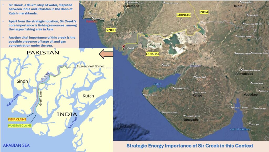
The Sir Creek dispute between India and Pakistan has long been dismissed as a minor maritime quarrel lost in the salt flats of the Rann of Kutch. In reality, it sits at the intersection of history, energy, and strategy. The estuary, about 96 kilometres long, winds through marshy terrain between India’s Gujarat and Pakistan’s Sindh provinces. Its alignment determines the maritime boundary — and, consequently, who controls a potentially resource-rich section of the Arabian Sea.
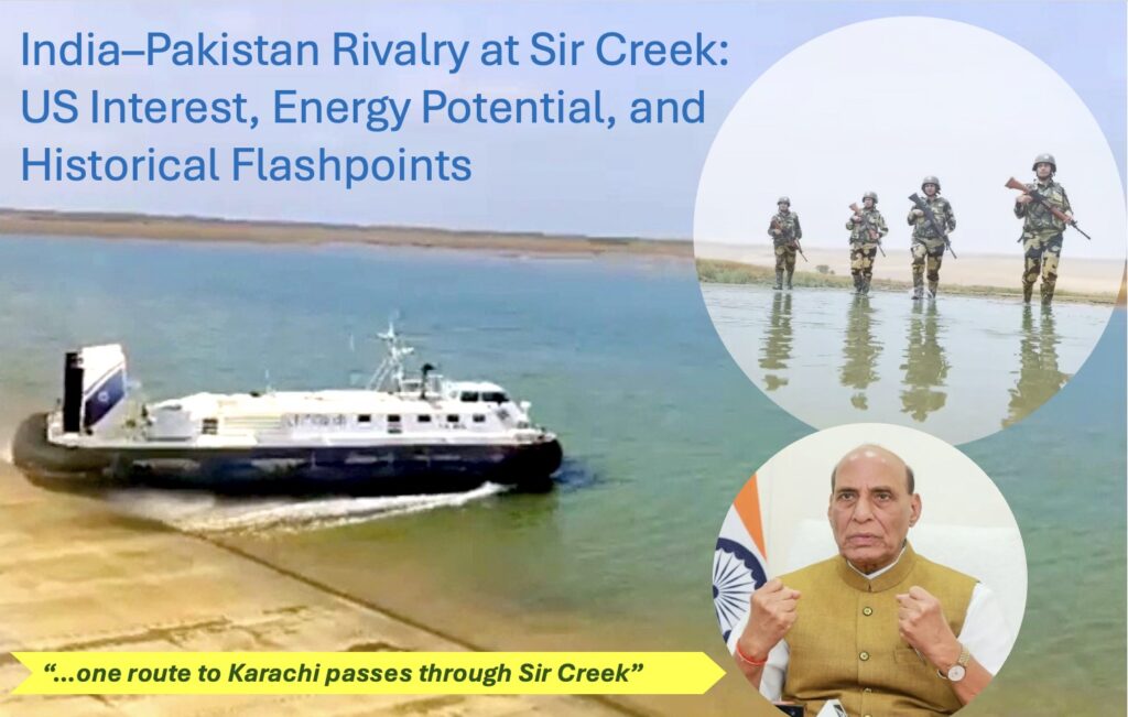
In the first week of October 2025, India’s Defence Minister Rajnath Singh resurrected the memory of the 1965 Indo–Pakistan War, warning that “one route to Karachi passes through Sir Creek.” The statement was not rhetorical bravado; it was a layered message aimed at deterring Pakistan, assuring domestic audiences, and signalling to external powers — notably the United States — that India’s regional posture would not be constrained by sanctions or foreign pressure.
Historical Background — From the 1914 Agreement to 1965
The origins of the Sir Creek dispute trace back to colonial cartography. In 1914, the then Government of Bombay and the ruler of Kutch signed a resolution demarcating the boundary between Kutch and Sindh (then under British India). According to India, the boundary runs along the mid-channel (thalweg) of Sir Creek, consistent with the 1914 Bombay Resolution. Pakistan, however, contends that the boundary lies along the eastern bank, which would place the entire creek within Pakistani territory and extend its maritime claim deeper into the Arabian Sea.
The issue remained dormant until 1947, when partition divided Kutch and Sindh between the two new nations. Tensions escalated during the Rann of Kutch skirmishes in April 1965, months before the full-scale Indo–Pakistan war. These clashes were sparked by Pakistani patrols entering what India considered its territory near Sir Creek. Although a ceasefire was brokered under British mediation, the region became an enduring symbol of military vigilance and national pride for India.
It was this history Rajnath Singh invoked in October 2025 — reminding Islamabad that provocations along Sir Creek could once again open a “route to Karachi,” a metaphor suggesting that India could retaliate deep within Pakistan’s heartland if its sovereignty was challenged.
Hydrology of Sir Creek — Dimensions and Tides
Sir Creek stretches nearly 96 km through the Rann of Kutch, with its width varying from a narrow 50–70 metres inland to nearly 2.5 km at the Arabian Sea mouth. Depths average 1.5–3 metres at high tide, reaching 5–6 metres in deeper pockets, but large sections dry into mudflats during low tide. The estuary follows a semi-diurnal tidal cycle, experiencing two highs and two lows each day, with a tidal range of 2.5–4.5 metres. Seasonal shifts also alter the creek’s hydrology: during the monsoon, flooding deepens and extends the tidal reach inland, while in the dry months, evaporation and siltation leave wide expanses exposed. These fluctuating conditions weaken Pakistan’s claim of navigability under the thalweg principle, reinforcing India’s position that the boundary lies along the eastern bank.
The Geopolitical Stakes — From Boundaries to Blue Economy
On the surface, the Sir Creek dispute concerns an estuarine border a few kilometres wide. In reality, it decides ownership of approximately 8,000 square kilometres of the adjoining Exclusive Economic Zone (EEZ) in the Arabian Sea — a maritime expanse with potential hydrocarbon reserves, rich fishing grounds, and strategic sea lanes.
Under the United Nations Convention on the Law of the Sea (UNCLOS), the EEZ grants a coastal state sovereign rights to explore and exploit natural resources up to 200 nautical miles from its baseline. A shift of even a few kilometres in the boundary can therefore translate into thousands of square kilometres of seabed jurisdiction — a decisive factor for both energy and security policy.
For Pakistan, gaining control over eastern alignment would expand its EEZ by nearly 2,000 square kilometres, extending its reach over suspected offshore oil and gas formations. For India, holding its claim means retaining exclusive access to a potentially energy-rich continental shelf and safeguarding the approaches to the Kandla and Mundra ports — critical gateways for trade and energy imports.
Energy Under the Sea — Oil and Gas Prospects in the Arabian Basin
The northern Arabian Sea, particularly the Indus Offshore Basin, is considered one of Asia’s largest unexplored deep-water hydrocarbon provinces. Over the past two decades, seismic surveys conducted by ExxonMobil, Shell, ENI, and Pakistan Petroleum Limited (PPL) have hinted at substantial gas-bearing structures beneath the seabed off Karachi and the Kutch coast.
In 2018, ExxonMobil — after nearly three decades of absence — re-entered Pakistan’s offshore sector, investing in the Indus Block G, which lies barely 150 kilometres southwest of the Sir Creek delta. Early seismic data suggested a potential gas structure comparable to the Sui field, one of Pakistan’s largest onshore deposits. Though drilling at the Kekra-1 well later proved non-commercial, geologists maintained that the region’s sedimentary thickness and geological continuity into Indian waters make it highly prospective.
For India, the area adjacent to Sir Creek falls within the Kutch Offshore Basin, which extends westward from Gujarat’s coastline. The Indian Directorate General of Hydrocarbons (DGH) has identified multiple deep-water exploration blocks within this zone. However, uncertainty over the maritime boundary has constrained private and international exploration activity, as investors are wary of operating near disputed waters.
Therefore, the dispute’s resolution could unlock a new frontier of offshore energy exploration — giving either side a strategic advantage in the emerging blue economy of the Indian Ocean region.
The U.S. Factor — Strategic Mediation or Energy Opportunism?
Washington’s periodic interest in Oil & Gas explorations in Pakistan, especially in the Sir Creek dispute is not purely diplomatic. It aligns closely with American energy geopolitics. The Arabian Sea coast of Pakistan offers potential deep-water drilling opportunities comparable to Oman and Iran, and U.S. oil majors see Pakistan as a more accessible, strategically located partner than some Gulf nations.
When President Donald Trump in May 2025 alluded to “facilitating mediation between India and Pakistan during Operation Sindoor,” New Delhi swiftly denied any such involvement. Yet, the timing of these statements — amid U.S. sanctions on Indian imports of Russian crude — raised eyebrows in strategic circles. Analysts noted that American rhetoric on peace in South Asia often coincides with U.S. corporate interests in the region’s energy corridors.
Trump’s Energy Policy on Pakistan
In July 2025, Trump announced an energy and trade deal with Pakistan on Truth Social, aiming to develop its oil reserves and reduce tariffs on Pakistani goods. He described Pakistan as having “massive oil reserves.” Observers also view the timing—following new tariffs on Indian goods—as a strategic move to exploit regional rivalries. Additionally, Trump’s interest appears to extend to Pakistan’s critical minerals and rare earth elements, crucial for US technology and defense, a point emphasized by Pakistani officials during White House visits.
By invoking Sir Creek and warning Pakistan in martial terms, India’s defence leadership effectively counter-signalled to Washington — asserting that India’s regional decisions are sovereign, and its deterrence posture will not be influenced by external economic coercion. In other words, New Delhi was communicating power to both Islamabad and Washington simultaneously.
Rajnath Singh’s Message — Deterrence, Symbolism, and Historical Echoes
When Rajnath Singh warned that “one route to Karachi passes through Sir Creek,” he was evoking the memory of 1965, when India repelled Pakistani incursions in the Rann of Kutch and later advanced toward Lahore and Sialkot. His statement carried three intertwined messages:
To Pakistan: India retains the capability and willingness to respond militarily to provocations, especially cross-border infiltration or maritime intrusions near Sir Creek.
To domestic audiences: The government stands firm in protecting national sovereignty and maritime interests.
To global observers, particularly the U.S.: India will not be drawn into externally imposed constraints or “mediated solutions.”
Sir Creek, therefore, has evolved from a cartographic dispute into a metaphor of deterrence — a reminder that even minor territorial challenges can invite disproportionate consequences.
Past Military Flashpoints — 1965 and After
The 1965 conflict was the most direct military engagement linked to Sir Creek. Pakistan’s Operation Desert Hawk attempted to occupy Indian posts in the Rann of Kutch, leading to intense skirmishes in April that year. India responded with ground and air operations, pushing Pakistani forces back to their pre-war positions. The subsequent British-brokered ceasefire awarded 90 percent of the disputed area to India, reinforcing New Delhi’s claim of administrative and military control.
Later, in 1999, during the Kargil conflict, Pakistani naval units again increased patrols near Sir Creek, while India strengthened its maritime surveillance network in the Kutch region. In 2011, both nations conducted a joint survey to finalise the land terminus of Sir Creek, but Islamabad refrained from signing the agreement, likely due to the EEZ implications that favoured India.
These recurring tensions illustrate that Sir Creek is not an isolated frontier but part of a broader pattern of testing boundaries and signalling resolve in the India–Pakistan rivalry.
Strategic and Economic Implications — What’s at Stake
Maritime Security:
Control over Sir Creek enhances surveillance and interdiction capability across the northern Arabian Sea, critical for protecting India’s western coast and offshore infrastructure.Energy Exploration Rights:
The boundary alignment determines ownership of potential oil and gas reserves, influencing national energy security strategies. A settlement in India’s favour could expand its EEZ by up to 8,000 sq km, opening new exploration zones.Fisheries and Livelihoods:
Hundreds of Indian and Pakistani fishermen are arrested each year for inadvertently crossing the unmarked maritime boundary. A clear demarcation would reduce humanitarian issues and economic losses.International Leverage:
For Pakistan, externalising the issue invites mediation, which it often seeks through Western capitals. For India, resisting such involvement preserves its bilateral dispute doctrine and reaffirms strategic autonomy.
Environmental and Security Dimensions
Sir Creek’s ecological importance also complicates the equation. The creek and its adjoining wetlands are breeding grounds for marine species and migratory birds. Military fortifications and surveillance activities have increased environmental stress, while unregulated fishing further depletes resources. Both nations occasionally discuss cooperative management, but progress remains minimal due to mutual distrust.
Moreover, the rise of maritime terrorism and smuggling routes through the Kutch–Sindh corridor adds a new layer of urgency. The 2008 Mumbai terror attack highlighted vulnerabilities along India’s western coastline. Enhanced monitoring of Sir Creek, therefore, is as much a security imperative as a territorial concern.
India’s Diplomatic Posture — Firm but Open to Dialogue
India maintains that the Sir Creek issue can be resolved bilaterally through existing mechanisms, provided Pakistan accepts the 1914 Bombay Resolution as the legal baseline. New Delhi has repeatedly proposed joint hydrographic surveys and technical-level talks but insists that maritime boundary negotiations must not be linked to unrelated political agendas, such as Kashmir.
Pakistan, by contrast, seeks third-party mediation, often citing the International Court of Justice (ICJ) precedent in other maritime disputes. However, India’s consistent position underlines that no external actor, including the U.S., has a role in bilateral territorial issues.
Conclusion — The Hidden Depths of a Shallow Creek
The Sir Creek dispute between India and Pakistan encapsulates the complex interplay of history, sovereignty, and energy geopolitics. What appears as a narrow channel of silt and salt carries within it the weight of national identity, military history, and strategic autonomy. Beneath its muddy waters may lie hydrocarbon reserves that could shape the energy future of both nations — making the stakes far higher than the geography suggests.
Rajnath Singh’s invocation of 1965 was thus not mere symbolism. It was a reminder — to Pakistan, to domestic audiences, and to external powers — that India’s patience is strategic, not infinite, and that its maritime boundaries are not lines for negotiation but lines of sovereignty.
In the emerging world order where energy, technology, and diplomacy converge, Sir Creek has become more than a border dispute. It is a test case of how nations defend their interests — not only on land and sea, but in the deeper realm of narrative and perception. For India, the message remains clear: deterrence and diplomacy can coexist, but autonomy is non-negotiable.